The devastating impacts of flood events across Texas underscore the urgent need for advanced flood preparedness and risk mitigation strategies. Faculty and students in the Texas A&M University Zachry Department of Civil and Environmental Engineering are tackling this challenge head-on, leveraging cutting-edge research in AI, complex systems modeling, and interdisciplinary collaboration to build a more resilient future. The work centers on shifting the focus from simply reacting to floods to proactively predicting and preventing human harm and infrastructural failure.
Predicting flash flood impact to save lives
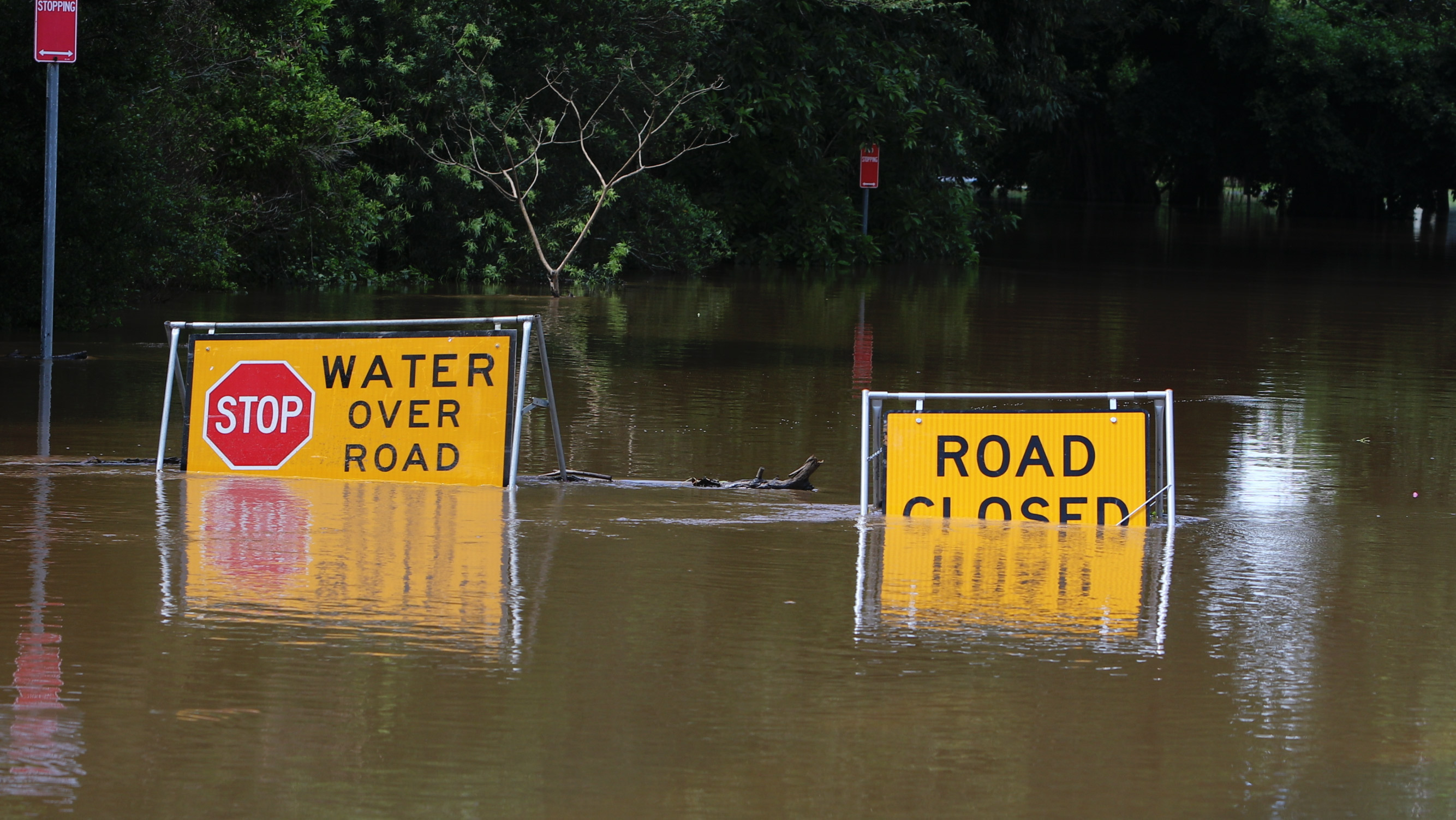
Flash floods are among the deadliest natural hazards in the U.S., but their localized and rapid nature makes issuing warnings difficult. Research led by Dr. Nasir Gharaibeh, in collaboration with former graduate students Shi Chang and Rohan Singh Wilkho, sheds light on the specific conditions that turn a localized flash flood into a deadly event.
"Flash floods are spatially small and localized, and only about 2% of events result in human harm," said Gharaibeh in reference to a study published in Natural Hazards.
The team focuses on identifying the climatic, environmental and situational factors that influence the likelihood of fatality or injury.
By analyzing thousands of flash flood events in Texas over a 15-year period, the researchers developed a sophisticated predictive model using rare-event logistic regression. This model considers factors such as nighttime events and locations in "flash flood alleys" — areas prone to sudden, severe flooding — to assess the likelihood of human harm. Such localized risk evaluation requires a deeper understanding of community and behavioral science, fostering interdisciplinary collaboration with experts in architecture, urban planning and public health.
We need a unique warning system that is very clear and differentiated from general flood warnings to be effective.
The goal is to move beyond general flood warnings toward a specialized alert system, similar to a tsunami or wartime alert, that effectively mobilizes people during a flash flood, even while they are asleep.
"We need a unique warning system that is very clear and differentiated from general flood warnings to be effective," Gharaibeh said.
AI and big data for near-real-time response
Research led by Dr. Ali Mostafavi harnesses the power of AI to transform disaster response and recovery. His Urban Resilience.AI Lab develops tools that leverage big data to provide near-real-time insights into disaster situations, augmenting human decision-making when every minute counts.
"Our research aims to analyze, model and improve network dynamics in the nexus of humans, disasters and the built environment to foster convergence knowledge of resilient communities," Mostafavi said. “When we develop these AI tools to collaborate with humans, the tools don’t make the decisions, but they can inform them.”
His lab utilizes predictive, analytic and generative AI across the disaster cycle. In the preparedness and mitigation phase, predictive models can anticipate which neighborhoods are most likely to flood. During an active flood event, AI systems can process diverse data — from rainfall sensors and satellite images to location-based cell phone activity — to monitor neighborhood-level evacuations, power outages and property damage.
“We know floods are becoming more frequent, but in a statistical sense, they are still rare events,” Mostafavi said. “The alternative to using actual historical flood data is to use physics-based simulations.”
Our research aims to analyze, model and improve network dynamics in the nexus of humans, disasters and the built environment to foster convergence knowledge of resilient communities. When we develop these AI tools to collaborate with humans, the tools don’t make the decisions, but they can inform them.
FloodGAN, a new model developed by his team, generates synthetic flood scenarios that they can use to create probabilistic maps that show the likelihood of an area receiving varying amounts of flooding. This rapid situational awareness helps emergency managers deploy search and rescue personnel and other critical resources where they are needed most.
During the recovery phase, AI models are also being developed to quickly assess impacts using high-resolution images from 360-degree, vehicle-mounted street view cameras. These cameras provide a different perspective to evaluate flood damage. An AI model analyzes the images to determine the lowest floor elevation, which helps show how far floodwaters have entered each building.
The street view technology, combined with satellite image damage assessments, provides a more robust and accurate toolset for rapid damage assessment in recovery efforts.
“Since publicly available Google Street View images are only collected once every few years, a more immediate deployment is necessary for post-flood damage assessments,” Mostafavi said. “My team deployed this technology in the field in areas impacted by the recent floods to aid recovery efforts and for research and development purposes.”
Bridging technology and practice in flood warning systems
The innovative models and technologies developed in the department are being rapidly translated into real-world applications by researchers like Dr. Jacob Torres.
"Our focus is on applied research and development, helping the public by bringing the latest technology and real-world applications together," Torres said. “What is the latest technology, and how can I use my knowledge of that research to bridge the gap and get it into the real world in an accelerated fashion?”
His work often involves assisting local entities, such as the Texas Department of Transportation, counties and municipalities, in securing grants and deploying comprehensive flood warning systems. He is also extending his applied research in flood early warning systems in collaborations with agencies like the Texas Division of Emergency Management, Rice University’s Severe Storm Prediction, Education, and Evacuation from Disasters Center, and the University of Texas at Arlington’s Water Engineering Research Center.
Our focus is on applied research and development, helping the public by bringing the latest technology and real-world applications together. What is the latest technology, and how can I use my knowledge of that research to bridge the gap and get it into the real world in an accelerated fashion?
These early warning systems utilize advanced computer modeling to replicate rainfall events, assess flood risk with physics-based analysis, and integrate with point-based measurement sensing. The goal is not only to model water flow, but to enhance communication and protect people from flood-related fatalities.
Torres emphasized the importance of practical experience for his students, who come from interdisciplinary backgrounds, including computer science, engineering technology and civil engineering.
"We want to train students with hands-on modeling experience, creating a streamlined partnership between consulting and academia," said Torres, who delivers regular seminars to the department on flood warning systems.
The convergence of predictive modeling, AI-driven insights, and the implementation of applied systems by the civil engineering department is defining a new era of flood resilience. By developing tools to predict flash flood lethality, provide near-real-time situational awareness, and deploy effective warning systems, Texas A&M researchers are working to reduce risk, enhance community preparedness and save lives.